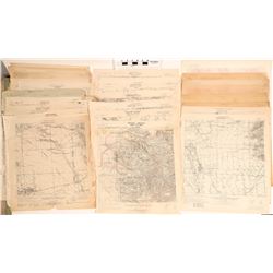
 2548 - Topographical Maps of Arizona (117839)
Holabird Western Americana Collections
These are two groups of maps; the first group is 625 scale; Dept. of Interior Geologic Society, (2 maps) Globe, 1901, 1902; Bisby 1910; Christmas 1917
Bidding Has ConcludedEstimate : 300.00 - 500.00
Sold to t********r for (75.00 + 18.75BP) = 93.75
Details...Bookmark
 2549 - Topographical Maps of Arizona (117838)
Holabird Western Americana Collections
This is a group of 22 maps at 6.25 scale of Arizona and bordering with California. Published by the Geologic Society 1927-1962: Needles, Cal. and Ariz
Bidding Has ConcludedStart Price : 130.00 | Estimate : 260.00 - 400.00
Details...Bookmark
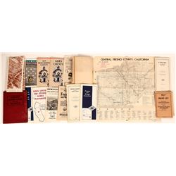 2550 - Misc. Maps, Mariposa, Fresno (119968)
Holabird Western Americana Collections
Hinton Exchange Club: dMisc. Maps - Fresno, Hammond's Handy Atlas of the World/Red hard bound book of maps/ published 1910 NY, C. S. Hammo...
Bidding Has ConcludedStart Price : 50.00 | Estimate : 100.00 - 300.00
Details...Bookmark
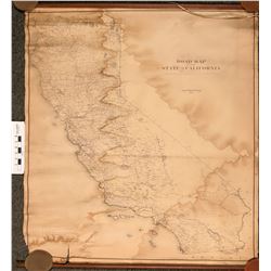 2551 - California Wall Map (120877)
Holabird Western Americana Collections
California 38"x 76" wall map showing the scant road system that existed back in 1910. Map is very old and in fragile but restorative condi...
Bidding Has ConcludedStart Price : 100.00 | Estimate : 200.00 - 300.00
Details...Bookmark
 2554 - Colorado Central Railroad Map 1885 (121151)
Holabird Western Americana Collections
This is a map of three sections of the Colorado Central Railroad depicting the Colorado Central from Denver west; The Georgetown Loop, and Georgetown
Bidding Has ConcludedEstimate : 100.00 - 200.00
Sold to S*****3 for (50.00 + 12.50BP) = 62.50
Details...Bookmark
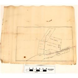 2555 - Copper Creek mining maps 1923 (120608)
Holabird Western Americana Collections
These are two mining maps of Copper Creek and Troy, Idaho; both are hand drawn on velum written by Joseph B. Wiply and E. J. Jones.
Date: 1923
Coun
Bidding Has ConcludedStart Price : 100.00 | Estimate : 200.00 - 400.00
Details...Bookmark
 2557 - Topographical Maps of Idaho (120602)
Holabird Western Americana Collections
These are topo. maps by the USGS: Sandpoint, 125 scale, R. U. Goode, 1901, 1941; Mountain Home, A.H. Thompson, 1893, 1916; Camas Prairie, A.H. Thompso
Bidding Has ConcludedStart Price : 100.00 | Estimate : 200.00 - 400.00
Details...Bookmark
 2558 - World Map / Multi Colored. (102094)
Holabird Western Americana Collections
Outstanding, multi colored map of the world. Beautiful color and definition . Showing new possessions, new boundaries, rivers, mountains seas, and ev
Bidding Has ConcludedStart Price : 50.00 | Estimate : 100.00 - 200.00
Details...Bookmark
 2559 - Minneapolis and Saint Paul Maps (120611)
Holabird Western Americana Collections
These are two maps of the Minneapolis and Saint Paul areas. One print is in velum at 30 in. X 48 in. scale is 1 in.=1600 ft. in fair condition maker u
Bidding Has ConcludedEstimate : 500.00 - 700.00
Sold to b***5 for (200.00 + 50.00BP) = 250.00
Details...Bookmark
 2560 - Missoula, Montana Map (120600)
Holabird Western Americana Collections
This is a map of the city of Missoula, Montana, no scale, Hale surveyor, 1928.Poor condition, fragile.
Date: 1928
Country if not USA:
State: Mont
Bidding Has ConcludedStart Price : 50.00 | Estimate : 100.00 - 200.00
Details...Bookmark