Great Americana Pow-Wow Auction (August 2020)

Auction CurrencyUSD Auction Location3555 Airway Drive Suite 309, Reno, Nevada, 89511, United States In Person PreviewPreview

Auction Details

We sincerely hope everyone is enjoying their summer!

This auction marks the best material we've offered in a hot August sale in many years. The variety is outstanding, as is the quality of goods offered.

A glimpse at the many categories: Native American turquoise and silver jewelry, including the best squash blossom necklace we've ever seen, baskets, Kachinas, and rugs; California token collection; Fauver American and foreign counters and tokens; rare whiskey bottles; Masonic California token; beautiful drugstore carved wood frontispiece; Nevada rare documents; major pinback collection; baseball and boxing collectibles; gold specimens including some from the Goodshaw Mine at Bodie; American and foreign medals; Victorian furniture; fantastic array of western Art; original Buffalo Bill/Pawnee Bill posters; Large ore cars and incline cars from a major Nevada City mine; Dynamite and candle boxes; American souvenir plate collection (c1900-1920); music collectibles; toys and toy trains; postcard collections, directories, maps; railroad pass collection and references; antique firearms; badges; mining & railroad stocks; US coins; token dies; a rockshop section, mining artifacts and much more.

There is truly something for everybody!

Don't forget us when its time to sell. We average about 5000 registered bidders per sale, probably the most in America for an Americana sale! With buyers all over the globe, we get to everybody. We are always after great collections! ~Fred Holabird~

Auction Schedule

Day 1, August 27th, 2020:
Art (1001-1093)
Native Americana (1094-1325)
General Americana Part I (1326-1595)
Sports (1596-1604)
Toys (1605-1651)

Day 2, August 28th, 2020:
Philatelic - Postal History (2000-2087)
General Americana Part II (2088-2599)
Firearms & Weapons(2600-2624)

Day 3, August 29th, 2020:
Stocks & Bonds (3000-3125)
Numismatics (3126-3416)
Tokens (3417-3634)

Day 4, August 30th, 2020:
Minerals (4000-4042)
Mining (4043-4320)
Bargains & Dealer Specials PART I (4321-4611)

Day 5, August 31st, 2020:
Bargains & Dealer Specials PART II (5000-5641)

SHIPPING & HANDLING: Shipping is subject to a minimum charge of $19.00. Shipping and handling cannot be estimated prior to invoicing as it is based on the size and weight of your purchase. Additional shipping and handling costs, if required, will be re-invoiced for the balance due. Items are not shipped until the invoice is completely paid. Many buyers purchase a number of lots. Every effort will be made to include all lots in a single shipping charge calculated to cover the weight and size.SHIPPING & HANDLING: Shipping and Handling cannot be estimated prior to invoicing, based on the size a...
Choose Your Layout > Switch to Grid View Switch to List View
Minneapolis and Saint Paul Maps  (120611)2559 - Minneapolis and Saint Paul Maps (120611)
Holabird Western Americana Collections
These are two maps of the Minneapolis and Saint Paul areas. One print is in velum at 30 in. X 48 in. scale is 1 in.=1600 ft. in fair condition maker u
Bidding Has Concluded
Estimate : 500.00 - 700.00
Sold to b***5 for (200.00 + 50.00BP) = 250.00
 
Details...Bookmark
Missoula, Montana Map  (120600)2560 - Missoula, Montana Map (120600)
Holabird Western Americana Collections
This is a map of the city of Missoula, Montana, no scale, Hale surveyor, 1928.Poor condition, fragile. Date: 1928 Country if not USA: State: Mont
Bidding Has Concluded
Start Price : 50.00 | Estimate : 100.00 - 200.00
 
 
Details...Bookmark
Grouse Mountain Mining Co. Maps Troy, Montana  (120605)2561 - Grouse Mountain Mining Co. Maps Troy, Montana (120605)
Holabird Western Americana Collections
This is a set of three mining maps of the Silver Grouse Mining claims out of Troy, Montana. Two are blue lines. Bimetallic mining. 1936 dates.C.H. Bar
Bidding Has Concluded
Start Price : 250.00 | Estimate : 500.00 - 1,000.00
 
 
Details...Bookmark
Map of the Judith Basin Montana Territory  (121157)2562 - Map of the Judith Basin Montana Territory (121157)
Holabird Western Americana Collections
This is a topo. map of the Judith Basin, Monana T. scale is 2 miles= 1 in., topographer was A.D. Wilson, Raphael Pumpelly director. Map is 23 in. X 44
Bidding Has Concluded
Start Price : 100.00 | Estimate : 200.00 - 400.00
 
 
Details...Bookmark
Map of the Judith Basin Montana Territory, Southern Sheet  (121158)2563 - Map of the Judith Basin Montana Territory, Southern Sheet (121158)
Holabird Western Americana Collections
Topographic map of the Judith Basin, Monana T. , southern sheet, scale is 2 miles= 1 in., topographer was A.D. Wilson, Raphael Pumpelly director. Map
Bidding Has Concluded
Start Price : 100.00 | Estimate : 200.00 - 400.00
 
 
Details...Bookmark
Coal Mining Maps for Washington State  (120612)2564 - Coal Mining Maps for Washington State (120612)
Holabird Western Americana Collections
This is a lot of mining maps in blueline and velum detailing the moving of roadway and leases for coal production. Interesting reading from 1928. Fiv
Bidding Has Concluded
Start Price : 50.00 | Estimate : 100.00 - 200.00
 
 
Details...Bookmark
Colville Region W. T. Map 1882. Pompelly2565 - Colville Region W. T. Map 1882. Pompelly
Holabird Western Americana Collections
Part of the Northern Transcontinental Survey, Raphael Pompelly. Pompelley was a major mining engineer, grad of Freiberg School of Mines, who worked
Bidding Has Concluded
Start Price : 100.00 | Estimate : 200.00 - 400.00
 
 
Details...Bookmark
King County Limestone Claims map  (120604)2566 - King County Limestone Claims map (120604)
Holabird Western Americana Collections
This is a claims map of King County, Washington for limestone claims, surveys by J. L. McPherson. Scale is 1 in = 400 ft., 1924. Very good condition.
Bidding Has Concluded
Start Price : 25.00 | Estimate : 50.00 - 100.00
 
 
Details...Bookmark
Map of Yakima Region Washington Territory  (121159)2567 - Map of Yakima Region Washington Territory (121159)
Holabird Western Americana Collections
This is a map of the Yakima area, W. T., Northern Transcontinental Survey, by Raphael Pumpelly, Wilson and Goode cartographers, 1882, Julius Bien prin
Bidding Has Concluded
Start Price : 100.00 | Estimate : 200.00 - 400.00
 
 
Details...Bookmark
Northern Transcontinental Survey Maps, by Raphael Pumpelly, Washington Territory  (121156)2568 - Northern Transcontinental Survey Maps, by Raphael Pumpelly, Washington Territory (121156)
Holabird Western Americana Collections
This is a collection of four maps; one for the Forest Department, and three for the Agriculture Department of Washington Territory 1883, printed by Ju
Bidding Has Concluded
Start Price : 150.00 | Estimate : 300.00 - 600.00
 
 
Details...Bookmark
Wyoming State Map from 1892  (120886)
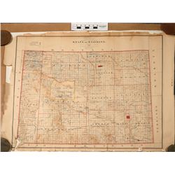
2569 - Wyoming State Map from 1892 (120886)
Holabird Western Americana Collections
A great map of the state of Wyoming measuring 32"x 40". the map has some frayed edges, which only add to its character and charm. A great ...
Bidding Has Concluded
Estimate : 200.00 - 400.00
Sold to d*******f for (100.00 + 25.00BP) = 125.00
 
Details...Bookmark
Topographical Maps of the North West Territories  (120607)2570 - Topographical Maps of the North West Territories (120607)
Holabird Western Americana Collections
This is a collection of 16 maps of the North West Territories in Canada: McKenzie River at Providence to Simpson, scale 1 in.=4 miles, inclination is
Bidding Has Concluded
Start Price : 250.00 | Estimate : 500.00 - 700.00
 
 
Details...Bookmark
Map of North America 300 years old  (113585)2571 - Map of North America 300 years old (113585)
Holabird Western Americana Collections
This is a great color map, c.1700, titled "North America From the Best Authorities." See San Francisco Bay labelled as "Sir Francis D...
Bidding Has Concluded
Estimate : 300.00 - 500.00
Sold to d********8 for (160.00 + 40.00BP) = 200.00
 
Details...Bookmark
Maps of Montana, Wyoming, and Utah 1st and 2nd editions  (120603)2572 - Maps of Montana, Wyoming, and Utah 1st and 2nd editions (120603)
Holabird Western Americana Collections
USGS Reconnaissance maps, 125 scale, Jensen, Utah, Col. , E.S. Snell, 1910, cloth back; Canyon, Wyo., 125 scale, H. Gannett, 1911, 1928; (2 maps) B
Bidding Has Concluded
Estimate : 300.00 - 500.00
Sold to d*****I for (160.00 + 40.00BP) = 200.00
 
Details...Bookmark
Maps Various States  (116944)2573 - Maps Various States (116944)
Holabird Western Americana Collections
Map of Nevada, New York, New Jersey, Ohio, Indiana, Iowa, Missouri, Maryland, Baltimore, Pennsylvania (5) Date: Country if not USA: State: City
Bidding Has Concluded
Start Price : 400.00 | Estimate : 800.00 - 1,000.00
 
 
Details...Bookmark
Northwest United States Maps  (120885)2574 - Northwest United States Maps (120885)
Holabird Western Americana Collections
Four maps of the northwestern United States, including Montana and Washington. Maps measure 26"x 40", 30"x 40", 22"x 30&qu...
Bidding Has Concluded
Start Price : 75.00 | Estimate : 150.00 - 200.00
 
 
Details...Bookmark
The Map of the Extermination of the American Bison 1889 Julius Bien  Co.  (120626)2575 - The Map of the Extermination of the American Bison 1889 Julius Bien Co. (120626)
Holabird Western Americana Collections
This is a map (18 in. X 24 in.) of the systematic demise of the American Bison dated 1889 prepared by W. T. Hornaday and printed by Julius Bien. The e
Bidding Has Concluded
Estimate : 300.00 - 600.00
Sold to d********8 for (375.00 + 93.75BP) = 468.75
 
Details...Bookmark
Automobile Road Map of California 1915  (120882)2576 - Automobile Road Map of California 1915 (120882)
Holabird Western Americana Collections
This 1915 California road map was published by The Automobile Club of Southern California. The map measures 18"x 49". Piece is in decent c...
Bidding Has Concluded
Estimate : 50.00 - 100.00
Sold to h*******i for (85.00 + 21.25BP) = 106.25
 
Details...Bookmark
Pikes Peak, Colorado Springs, Manitou Early Tourist Brochures and Postcards (9 pieces)  (120940)2577 - Pikes Peak, Colorado Springs, Manitou Early Tourist Brochures and Postcards (9 pieces) (120940)
Holabird Western Americana Collections
1) Scenic Views of Pikes Peak, Sentinel of the Rockies, A Story Told in Pictures. 20 colorful 5.5" x 7" photographs in 8.5" x 9"...
Bidding Has Concluded
Estimate : 100.00 - 150.00
Sold to d*******f for (55.00 + 13.75BP) = 68.75
 
Details...Bookmark
New York City & State Maps & View Publications (2)  (122270)2578 - New York City & State Maps & View Publications (2) (122270)
Holabird Western Americana Collections
1) Rand McNally Pocket Maps for Tourists, Travelers & Shippers, General and Commercial Business Reference. 1931. Contains counties, cities, tow...
Bidding Has Concluded
Estimate : 80.00 - 160.00
Sold to 8********l.. for (45.00 + 11.25BP) = 56.25
 
Details...Bookmark